El Niño to Dominate Fall Weather
Southern regions may catch up on moisture levels while northern areas may get chilly now and then.
Southern regions may catch up on moisture levels while northern areas may get chilly now and then.
Weather forecasters agree that El Niño will be one of the driving forces of this fall’s weather. It has already warmed the waters off the coast of South America and through the equatorial Pacific Ocean. As fall sets in, the jet stream will likely split and one part will go across the southern tier of states and another will flow over the plains states and then drop back down over the Great Lakes.

John Baranick, Ag Meteorologist, DTN
This does two things, according to John Baranick, ag meteorologist with DTN, a subscription-based weather and agricultural news service. “For the southern region of the U.S., we’ll likely see more storms so there’ll be better chances for precipitation. These will increase throughout fall which hopefully will give us good moisture for planting winter wheat which we haven’t had the last two seasons.
“We’re forecasting above-normal temperatures in September and below-normal temperatures in October and November for the bulk of the Corn Belt. East Coast and southern states will be fairly wet.”

Matthew Rosecrans, Meteorologist, NOAA’s Climate Prediction Center
Matthew Rosecrans is a meteorologist at NOAA’s Climate Prediction Center. His team develops new scientific methods or incorporates scientific methods developed by research and academic partners to create forecasts from two weeks to two years ahead. He’s also involved with hurricane, temperature and precipitation outlooks, and drought forecasting.
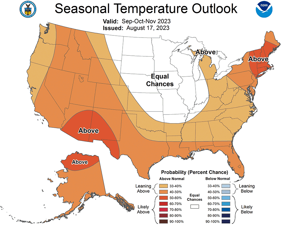
“Central Kansas, most of the Dakotas, Illinois and Wisconsin have no strong climatological signals for either above- or below-normal temperatures,” Rosecrans says. “Moving east toward Ohio, Kentucky, then wrapping around to northern Arkansas, Oklahoma and Colorado, odds increase for above-normal temperatures.

Courtesy NOAA Climate Prediction Center
“We may see some freezing in western Iowa and eastern Nebraska in September, though the median time for a 32° freeze is in October for most of this region.”
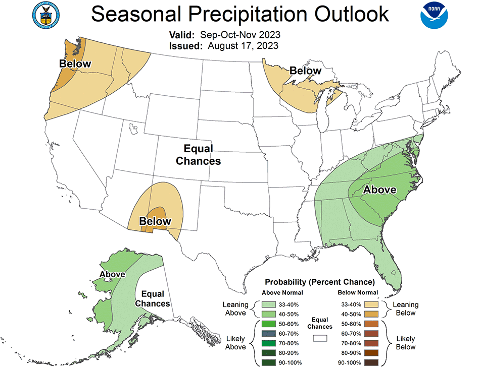
Rosecrans adds his team favors some above-normal precipitation this fall for the area from eastern Nebraska southeast to Arkansas because of low-pressure systems that will move through. This implies there could be an active storm track across this region, but it’s not possible to predict each storm now.

Courtesy NOAA Climate Prediction Center
Kansas and Oklahoma are split down the middle with the eastern halves of each state expected to get above-average rainfall. The prediction for the western halves of each state shows no signal to expect a departure from normal.
Colorado is likely to have below-normal precipitation, but this can be attributed more to reduced monsoonal flow than El Niño.
Precipitation for most of the Corn Belt during El Niño is typically normal. What rain does come before the ground freezes will help rebuild subsoil moisture, which is used less by this time of the year anyway.
“It may not show up on the drought monitor yet, but as crops start to mature, there’s less transpiration taking place and a lot more rainfall goes into recharging the soil,” Baranick says. “There’s a good chance we can build subsoil moisture at least through August, though we’ll have a mellower pattern afterward.”
He adds that drought has been in many areas for a while and subsoil moisture may get restored with fall rains. The drought may not disappear, but it will be significantly reduced.
“We can still have good topsoil moisture for winter wheat growth in the Midwest and Central Plains,” Baranick says. “We could even see muddy fields here and there that cause a few delays, but I don’t foresee any big hazards. El Niño is generally a good thing for most folks.”
If colder air hits earlier this fall, there could be an early snowstorm in the Dakotas or upper Midwest, but it’s too early to bank on that.
El Niño is as significant to South America as it is to North America. Baranick says El Niño favors better weather conditions for Argentina and Brazil, so there may be a boost to crops and exports from those countries next year.
El Niño tends to hurt wheat, especially in eastern Australia. Baranick says as wheat starts developing over the next two months, the heat and dryness may become an issue resulting in less and perhaps lower-quality wheat. This may turn into a marketing opportunity for U.S. wheat growers.
Predictions are great planning tools and accurate ones are even better. Scott Eversgerd is a Pioneer Field Agronomist in southern Illinois. Customers in his region grow corn, soybeans and wheat, and it’s been a season full of weather-related challenges. Drought challenged them earlier in the season, but rains around July 4th brought redemption to most crops in the area. One part of his territory was extremely dry in June and there were doubts about crop survival. However, 15” to 18” inches of rain fell from mid-July to mid-August, pumping life into plants.
The lack of local weather forecast accuracy has frustrated many farmers, but Eversgerd says everyone understands weather varies greatly and often. In the same breath, he acknowledges having at least six weather apps on his phone so he can get what seems to be the most accurate forecast. Customers are no different.
“As we look at our normal, full-season corn crop and our full-season soybean crop, even if we have an early frost, it looks as if we will have outrun most of our concerns,” Eversgerd says. “Right now, our biggest concern from a frost standpoint is the double-crop soybeans. Most of them went into the ground after June 20th. They’re still flowering and won’t mature until early mid-October. If we get frost the first week of October, it can ding those beans hard.”
“We typically get a fairly dry September and as October rolls in, we’ll likely get a cold front that cools things off,” he says. “Things turn more winter-like around November 15th and we can then get a five-, six- or seven-day rainy, cold spell. Things like this damper any harvest left, but most folks finish by the first week of November. We had some muddy years in the 80s, but harvest has been good the last 10 or 12 years.”
Assuming the weather holds, Eversgerd doesn’t foresee any significant harvest issues. He says they’re seeing more weeds in some corn and soybean fields than they normally would, but when residual herbicides were sprayed in May and June, they weren’t getting any activating rainfall. Fortunately, he’s not observed enough weeds to limit yields.
It’s been a light year for insects, too. Eversgerd says nothing is expected to cause any harvest issue.
Harvest can go fast, especially when things are good.
“Fortunately, a lot of growers have had some pretty good years and bought machinery that operates efficiently and quickly,” Eversgerd says. “They have a lot of harvest capacity and machinery to match. So, if Mother Nature cooperates, we can get 60 percent to 70 percent of the crop harvested in three or four good weeks.”
As harvest draws near, Eversgerd says it’s especially important to watch harvest moisture levels in addition to monitoring forecasts.
“We know the highest relative yield comes from a harvest moisture in the 22 to 25 percent range,” he says. “Possible loss in kernel dry matter through respiration losses, also called Phantom Yield Loss, is possible, but physical losses are likely a bigger part of the yield loss due to the harvest equipment when the grain gets dry. And, when beans get into the harvest range of eight to 10 percent moisture, harvest losses from the machinery increase greatly.”
In addition to combines, grain carts and trucks, Eversgerd strongly recommends paying attention to grain systems and making sure they’re ready for harvest. “We push a lot of grain through augers and other equipment. Take some time for preventive maintenance on them to minimize downtime and loss.”
Remember the weather forecasting tools, too.
“We’re getting away from La Niña, which threw us some curves compared to El Niño which is more tolerable,” Baranick says. “It’s allowing growers to finish the work now and at harvest. Right now, I wouldn’t be too concerned about rushing to finish it early. This doesn’t mean folks shouldn’t pay attention to forecasts because things can change quickly.”
Rosecrans agrees and says this is not a time to throw weather caution to the wind.
“Pay attention to the latest forecasts from the National Weather Service, especially the one-week out and two-week out time periods,” Rosecrans says. “They offer good, actionable information that can be used at individual activity levels to firmly plan what you’re doing. They may prompt you to harvest a week early if inclement weather is coming or to delay it if an extended dry period is coming.
“Getting a daily feed of the latest weather information from the National Weather Service or other vendors will help keep you as current as possible. Make sure to stay updated because forecasts change. We’ll update our monthly forecast for September the last day of August.”
Local weather observations are critical. Rosecrans stresses the NWS relies heavily on technology and expertise to help create forecasts, but it also leans heavily on local expertise throughout the country.
“We have local experts from almost every state in the country,” he says. “They understand the climatology and impacts of our seasonal outlooks and what will happen to agriculture and the water supply during a season in their regions. We talk with them every time we issue outlooks.
“Personnel in National Weather Service offices talk with local partners daily and sometimes hourly with local growers, agricultural groups, emergency managers and local legislators. Integrating the local aspects with the national expertise, science and computing lets us get to county-level analysis for our maps and outlooks.”
Rosecrans and Baranick agree that regular checks of weather forecasts, combined with practical experience, will deliver optimal information, no matter how many weather apps and subscriptions you may use.
Stay connected to your Pioneer agronomist with our Walking Your Fields e-newsletter and other communications. It’s your go-to source for timely agronomic information to help add value to your farm management strategy.
Subscribe Now